
As system hardening focuses on updating overhead lines and equipment, PG&E has to consider over 30,000 line-miles of transmission and distribution assets in High Fire-Threat Districts in its operation. Industry-wide adoption of lighter, stronger, and/or more heat-resistant infrastructure has been limited by cost, availability and longevity.

Problem statement
Across the industry, vegetation management is a key component of risk reduction, particularly now and for years to come as system hardening and other longer-term risk-reduction efforts cannot be accomplished immediately. Though onsite vegetation work is critical, it is inherently constant, labor-intensive, and complex as both planned and unplanned management needs vary in scope and urgency and must be managed by a limited availability of qualified workers.
Possible approaches
Any technical solution or equipment innovation that reduces vegetation management labor costs is welcome. Novel, cost-effective approaches to surveying—limiting the pre-work design, planning and vegetation removal assessments—is one approach. Another area of interest is optimizing labor through automation, such as robotic or otherwise efficient and nimble vegetation pruning and removal, particularly in sloped, mountainous, and/or vegetation-heavy areas.
| Industrywide Market Gap | Potential Solution Category |
|---|---|
| Dispatched teams often have trouble simply accessing lines (e.g., hiking ravines, navigating and even cutting-through thick vegetation) to do pre-work design, planning, and vegetation removal assessments. | Cheaper and faster surveying of vegetation and access impediments via drone, radar, satellite images, etc. |
| Especially in sloped, mountainous and/or vegetation-heavy areas, it can be difficult and laborious (and hazardous) to perform manual vegetation pruning and removal. | Robotic or otherwise efficient and nimble vegetation pruning and removal |
Known approaches not of interest
Software-based and procedural/managerial solutions are not of interest.
Key success criteria
Required:
- At least 35% reduction in cost for the same wildfire risk reduction or at least a 35% reduction in wildfire risk at the same cost (see cost / risk reduction curve below)
- Demonstrated improvement of current state of the art technology
Desired:
- Capable of 3-D mapping and/or pruning vegetation of varying heights in difficult terrain, such as steep slopes and mountainous ravines
- Commercially deployable in 1 to 3 years
- Labor and safety-enhancing technology (i.e. autonomous equipment)
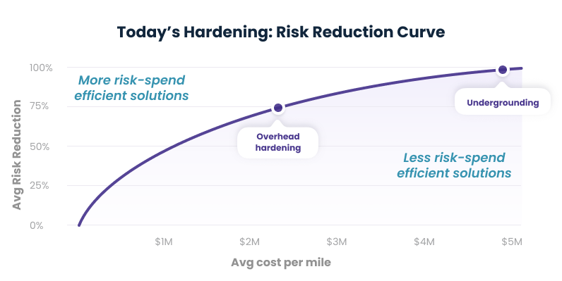
*Note that this graph is illustrative and not necessarily representative of current costs.